Single Object Maps
Maps for single texts: Single-object-maps
Based on the information and data, which are organised within the database, visualisations are generated for single objects and texts as well as for statistical surfaces. The maps are generated automatically, on the fly (those maps do not exist as images, they are created with any desired content, depending on the user’s needs). Literary settings follow their genuinely own rules. There are at least four aspects that make fictional spaces so unique – and consequently so difficult to map. First, they are fragmentary. The spatial dimension in fiction is constructed by the power of words, it has to be completed and filled by the imagination of readers (unlike photographs, paintings or movies where for instance a view/a panorama can be visualised entirely, with no gaps). Second, narrated spaces do not have definite borders. Thirdly, fiction is sometimes hard to localise. A setting can be located 'somewhere', with no precise correspondences to a given section of geospace. Furthermore, there are several transformation technics, like for instance renaming of places, synthesised or translated places. Altogether one must state that we are dealing with an imprecise geography of literature – and this forms a huge challenge for cartography. In order to map elements of the fictional space including their above specified characteristics, experiments have been conducted regarding a number of visualisation techniques: for instance fuzzy shapes (to meet the indefinite, fragmentary extent of settings) and a purpose-built colour coding scheme(to depict the various degrees of transformation). In the following, a couple of prototype visualisations and schemes shall serve as illustrations:
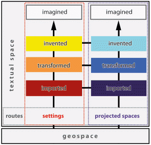
• Colour coding scheme: A colour-coding scheme has been devised to categorise settings into one of the following categories: »imported«, »transformed« or »invented«. The colour scale representing settings is held in warm colour hues. In the contrary, cold colour hues are used to represent projected places. This leads to a matrix of 2×3 colour fields, used for visualisation of the literary spatial objects »setting« and »projected places« and their relation to geospace.

Figure 1: Colour Code of settings and projected places regarding their reference to geospace
• Fuzzy shapes: Fuzzy shapes are geometric forms without precise boundaries. In this way they appropriately represent the geographic spaces of literature, which have key elements but can only rarely be precisely delimited. Fuzzy shapes are intended to portray places that are only vaguely known in their spatial dimensions. Fuzzy shapes results from a colouring that is gradually fading with increasing distance from the centre. Their colour is determined according to the above categories.
Challenges
• Historic changes of the geospace as reference point: A new area in which work remains to be done involves the digital processing of historical maps. Geospaces to which literary settings might refer are subject to constant change, while urban spaces are obviously affected to a larger extent than rural areas. The existing collection of scanned historical maps needs to be prepared and linked to the system, so that future users may call up illustrations showing them how the geospace looked during the time of the narrative (e.g. some nineteenth-century Prague novels were set in locations that at the time were outside the city limits, in green valleys and forests. If these settings were indicated on a contemporary map of Prague, they would appear to be in the middle of densely populated city districts). Also the topic of historically shifted political borders, particularly significant for Europe, needs to be considered when it comes to the preparation of base maps (e.g. the collapse of the Austrian-Hungarian Empire; opening of the former inner German border). Essentials impulses could be taken from the field of History GIS, which deals with the changing geographical shapes of countries.
• Switching the scale: Another problem is related to the repeated »zooming effect«, that literary texts confront us with. The perspective can change quickly from an almost microscopic focus – a house, even a room – to sudden leaps into the global dimension. In order to serve the purposes of the »Literary Atlas of Europe« there is clearly a need to experiment with differently-scaled maps. The visualisation of single settings has to be customized depending on the respective scale; in some cases, it might be indispensable to simplify the symbolisation. Small-scaled maps of Europe or the world emphasize the broader horizons of fictionalized spaces, while large scaled maps (especially of urban spaces, such as Prague) highlight the very detailed interactions between single settings, including buildings.
• Density of settings: The varying density of settings poses another challenge. Several hundred settings per text arranged in a small geospace are quite frequently to be found in historical novels set in Prague. At the other end of the scale are texts that are located in only one setting or in a few scattered settings, far away from each other. It is necessary to find solutions of how to map the overlapping settings in detail as well as of how to focus on relevant localities if there are only a few settings. One option might be to use cartograms which distort certain spatial units proportionally according to their importance, another to apply displacement algorithms, particularly for the automatic positioning of type.

